


depart le belieu vers le mont repentir

gerardmicheline
User
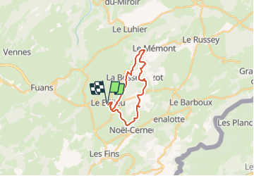

Length
19.1 km

Max alt
1065 m

Uphill gradient
450 m
Km-Effort
25 km

Min alt
886 m

Downhill gradient
450 m
Boucle
Yes
Creation date :
2021-10-08 08:01:00.171
Updated on :
2021-10-08 08:01:43.044
5h41
Difficulty : Very difficult

FREE GPS app for hiking
 SityTrail
IGN / Geographical institutes
SityTrail Plus
The world is yours!
About
Trail Walking of 19.1 km to be discovered at Bourgogne-Franche-Comté, Doubs, Le Bélieu. This trail is proposed by gerardmicheline.
Positioning
Country:
France
Region :
Bourgogne-Franche-Comté
Department/Province :
Doubs
Municipality :
Le Bélieu
Location:
Unknown
Start:(Dec)
Start:(UTM)
320628 ; 5221157 (32T) N.
Comments